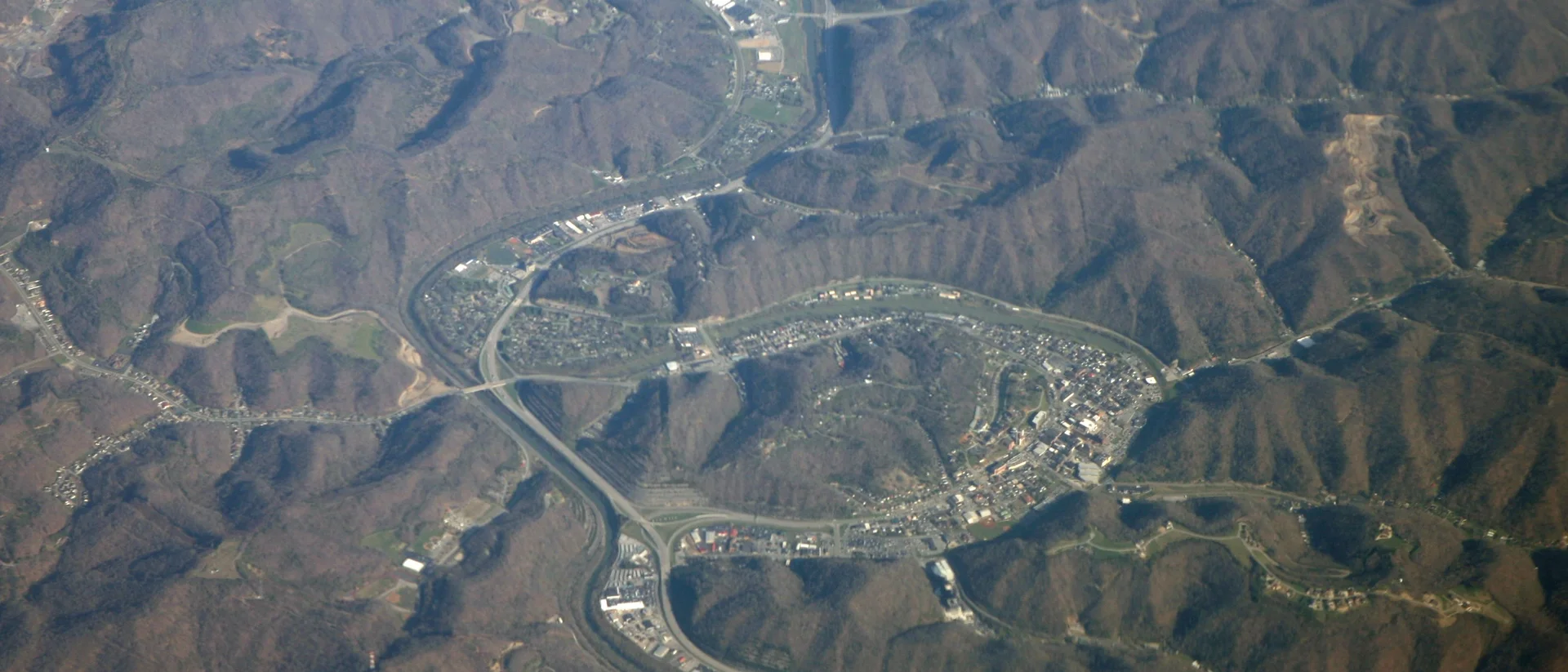
Pikeville, Kentucky, is a coal town of about 5,000 people. A river wrapped around downtown, flooding it almost every year. So the town moved the river. For 14 years, crews cut a channel through a mountain, 523 feet deep. A highway, railroad, and river now run through it side by side. The flooding stopped. They paved a new road over the old railbed and named it after the doctor who pushed for it for over a decade.
This Coal Town Cut Through a Mountain to Stop Flooding
Every spring for decades, the people of Pikeville, Kentucky, watched the Levisa Fork rise out of its banks and pour into their downtown. Rather than keep building higher floodwalls, the small coal town decided to try something almost nobody attempts: move a mountain out of the way.
A River That Wouldn't Stay Put
Pikeville sits in the heart of Appalachian coal country, in a bend of the Levisa Fork of the Big Sandy River.
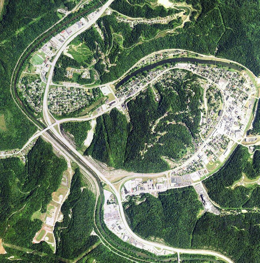
The river snaked in a tight loop, or oxbow, around the entire downtown. Almost every year it flooded homes, stores, and the coal-hauling railroad tracks that ran through the middle of town.
The idea to fix it started small. In 1960, a local doctor named William Hambley - who was also Pikeville's longtime mayor - first proposed moving the railroad tracks out of downtown, mainly to stop coal dust from trains settling over the city every day.
By 1963, Pikeville had landed a federal grant to study relocating the railroad. The town was also named a "Model City," which brought in more funding.
By 1965, the plan had grown much bigger. It was no longer just the railroad - a new four-lane highway and the river itself would be rerouted too, all through a channel cut straight through Peach Orchard Mountain.
Fourteen Years With Dynamite and Bulldozers
Construction began on November 26, 1973, and it did not finish until October 2, 1987.
In the first phase, crews blasted nearly 13 million cubic yards of rock out of the mountain to open a channel for the road, railroad, and river.
Starting in 1980, the second phase rerouted the Levisa Fork itself out of its old oxbow and into the new channel, then filled in the abandoned riverbed to create 240 acres of flat land in the middle of downtown.
The final phases, beginning in 1983, added highway interchanges, floodwalls, a new bridge, and a boulevard built on top of the old railbed. They created another 150 acres of usable downtown property.
By the time it was dedicated in 1987, the project had moved nearly 18 million cubic yards of soil and rock in total, at a cost of $77.6 million - about $220 million today.
The University of Kentucky's Kentucky Geological Survey has described it as "a 14-year engineering achievement second only to the Panama Canal."
That comparison has become local legend, though it doesn't hold up strictly by volume. French and American crews together excavated roughly 47 million cubic yards for the Panama Canal - 30 million by the French before 1889, then 17 million more by the Americans - well beyond the 18 million cubic yards moved at Pikeville.
What isn't in dispute is that the Cut-Through remains one of the largest earthmoving projects ever completed by a town its size.
The Doctor Who Wouldn't Let It Go
Hambley pushed the idea for more than a decade before a single truckload of rock moved. When the project's final phases wrapped up, the road built on the old railbed through downtown was named Hambley Boulevard in his honor.
What Pikeville Got Back
The town of roughly 5,000 people got 390 acres of new, flat, buildable land where a flood-prone riverbed and rail yard used to sit.
More importantly, the almost-yearly flooding that had plagued downtown Pikeville for generations stopped for good.
Today, the Cut-Through still carries US 23, a CSX rail line, and the Levisa Fork side by side through solid rock - and locals still bring visitors to the overlook above it just to watch the road, the railroad, and the river pass through the gap a coal town cut with its own hands.
Enjoyed this fact?
Be the first to love this
Get a new fact every morning.
A fascinating fact in your inbox every morning. Free. Unsubscribe anytime.
Frequently Asked Questions
What is the Pikeville Cut-Through?
Why did Pikeville, Kentucky cut through a mountain?
How long did it take to build the Pikeville Cut-Through?
How much material was moved during the project?
Who is Hambley Boulevard in Pikeville named after?
Verified Fact
Verified Aug 20, 2026 · 2 sources checked
Source: Kentucky Geological Survey, University of KentuckyShow verification details
Claims checked
- Project took 14 years (1973-1987)
- Channel cut 523 feet deep, rerouted Levisa Fork
- Highway and railroad also moved through the cut
- Total excavation about 18 million cubic yards
- Panama Canal comparison corrected to French and American combined excavation
Sources: Kentucky Geological Survey, University of Kentucky, Wikipedia
Related Topics
More from Places & Culture
View all Places & Culture →